Building Local Urban Ecologies
Shruti Syal, Ph.D.
Systems researcher—via Biology, Environmental Sciences, and Urban Planning—with 15 years studying human-environmental interactions and urban resilience in projects across India, United States, Canada, and Oman.
How network maps can build resilient green cities
TEDxVCU
Project 1: ACWUS
Artificially Constructed Wetlands for Urban Sewage treatment is a study based in Delhi, India, spanning 14 years (ongoing), starting as a national student competition-winning Master’s project (2011) and an award-winning PhD dissertation (2019), now being expanded upon with major university research grants (2022, 2024).
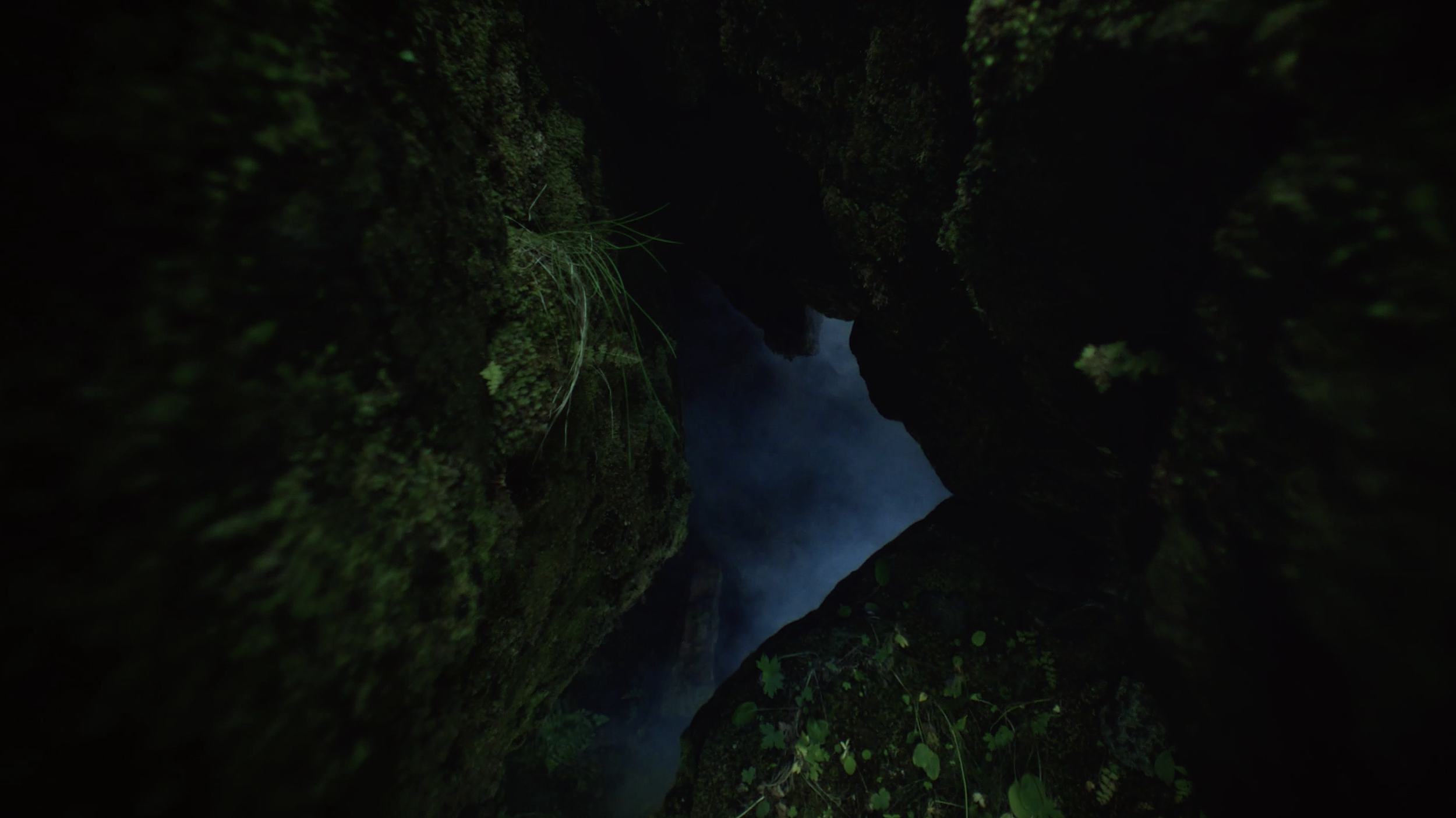
Picture by Shruti; from fieldwork while walking along a ‘minor’ drain (2018)
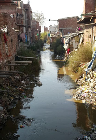
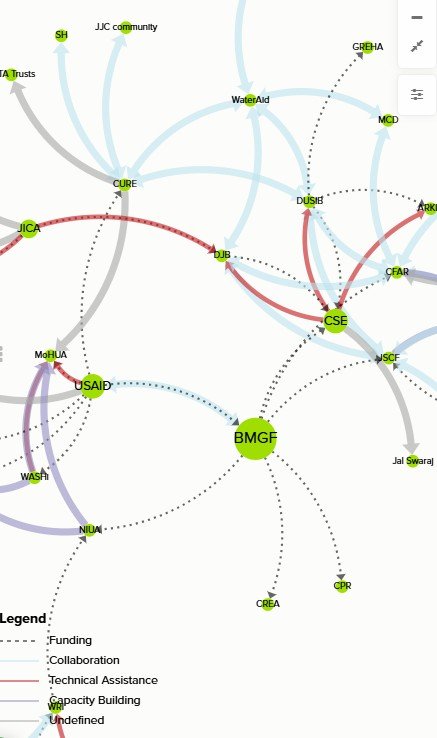
Nature-Based Solutions (NBS) like constructed wetlands could help us realize our vision of WaSH (Water Sanitation Hygiene) in ‘informal’ settlements, without compromising water quality in the adjacent stormwater drains and the river Yamuna that they flow into. My analysis of water quality and adjacent land uses around Delhi's drains destabilize the case that the poor pollute, identifying them as more the recipients of upstream pollution from ‘formal’ land uses (Syal, 2024). An institutional analysis of urban service access in informal settlements then showed how regulatory overlap cripples infrastructure/service providers, not just users (Syal, 2025), laying the groundwork for the need to map the network (ongoing) of the many international, national, and local actors dictating WaSH access and NBS deployment in 'informal’ settlements. This Social Network Mapping and Analysis of the major urban service chains (water, wastewater, stormwater, sanitation, solid waste, pest control, electricity) is not only consolidating the actions, roles, and interactions between hundreds of state and non-state actors, but also the hundreds of instruments (Plans, Policies, Legislations, Programs) guiding them.
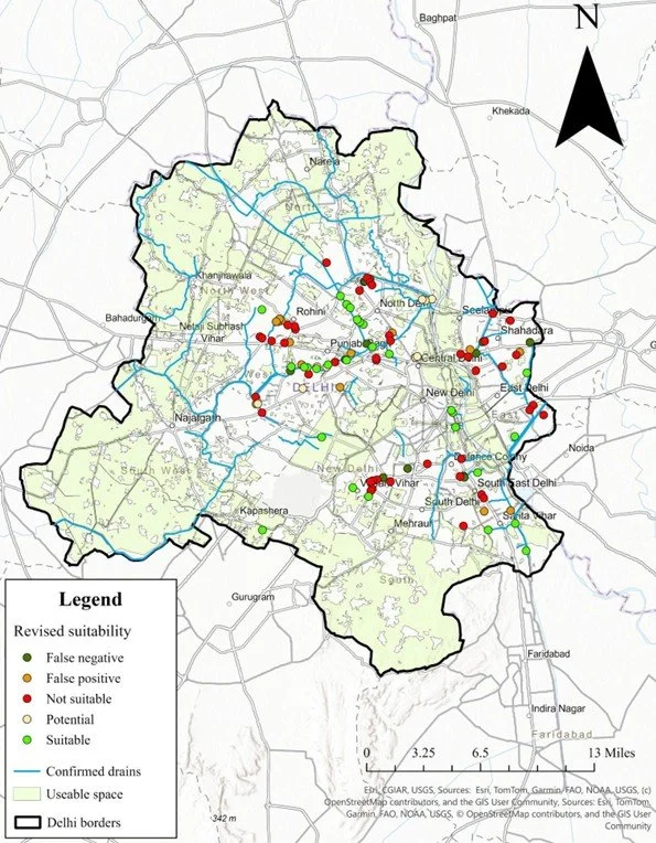
This network map (Syal, manuscript under preparation), along with an innovative GIS suitability analysis for DEWATS (decentralized wastewater treatment systems) that identified at least 28 drain-adjacent settlements suitable for NBS (Syal & O’Grady, under review), will serve as an unforeseen resource to understand what is needed to make this complex system of water, waste, drains, communities, and institutions, etc., resilient.
This project has been funded by the Indian Institute of Human Settlements (~$5,000 over 2011-2014), the Campus Research Board grant (~$24,000 over 2014-2015) and Hopkins Fellowships at University of Illinois at Urbana Champaign, and the Wilder School Small Grant ($10,000 over 2022-2023) and Quest Fund grant (~$50,000 over 2024-2026) at Virginia Commonwealth University.
More information coming in Summer 2026
Project 2: UGERP
The Urban Green Equity and Resilience Project is a study based in Richmond, VA, taking a systems approach to connecting the city’s green infrastructure spatially, institutionally, and humanistically.

Picture by Shruti; during the first UGERP Research Team Retreat at the VCU Rice Rivers Center (2024)
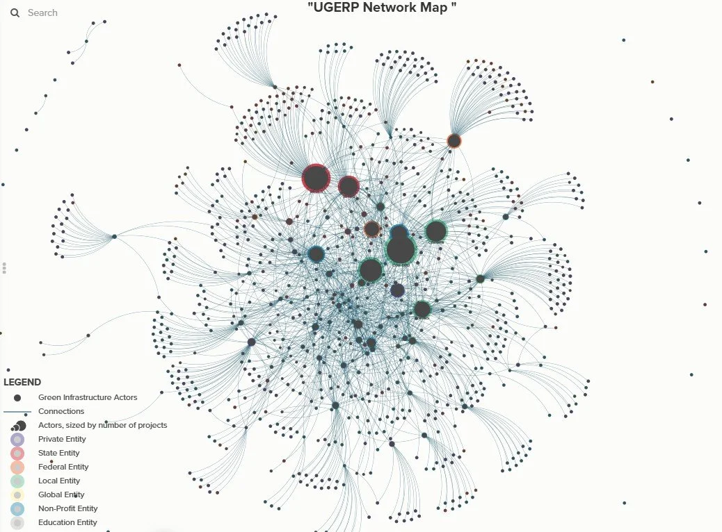
UGERP is an interdisciplinary, multi-stakeholder, community-focused project to map RVA's ecological capital (green infrastructure GI/GSI) and social capital (network of hundreds of affiliated actors and their interactions) (Syal, Ciminelli & Lewis, manuscript under preparation). These deliverables are produced to help these actors better coordinate and plan an integrated GI/GSI network to enhance urban resilience against multiple interrelated shocks: flooding, UHI, food insecurity, and more. The implementation partner is PlanRVA, regional planning agency for Central VA, that is currently completing its Natural Resources Plan, a hallmark regional planning effort by the agency.
This project has been funded by Virginia Commonwealth University's Institute for Sustainable Energy and Environments and Humanities Research Center ($21,000 over 2022-2023) and Breakthroughs grant ($200,000 over 2024-2026).
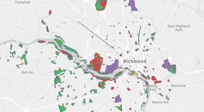
We have produced a GIS map of 167 urban greening sites (link coming in 2026) across local, neighborhood, and city scales (co-PI, Jennifer Ciminelli), and a network map of 945 civic, governmental, private and NGO actors (link coming in 2026) engaged in these spaces in various ways. We are currently conducting fieldwork (co-PI, Dr. Lillian Lewis) and interviews to understand these sites and the human, nonhuman, and nonliving assets and activities that contribute to resilience and belonging in these spaces. We will share our findings and make these resources available with an innovative multi-media installation that will be open to the public at the conclusion of this project (Syal & Lewis, ongoing).

Picture by Shruti; pausing at the Emancipation and Freedom Monument at the Canal Walk, one of the 10 GI sites selected for field observations (2022)
More information coming in Fall 2026
Project 3: Interdisciplinary, Experiential, Global Learning
In Fall 2008, sitting in Leacock-132 in McGill, I took a career suggestion by Suzzane Fortier, then-President of the National Science and Engineering Research Council, to heart. She said that interdisciplinarity was the nom du jour, but that we must base ourselves in a discipline to be able to form connections to others.
I tried, and failed, at that. As I moved from human anatomy to molecular biology, to ecology, to environmental studies, to urban studies, I struggled to find a niche that could be my base. I was an intellectual nomad until I found systems theory that gave me the ability to keep unraveling every thread of the story I researched, without being halted by disciplinary, data, or methodological boundaries.
Cities are complex systems, their resilience an emergent property of interconnected variables that requires such continual exploration, unimpeded by spatial, temporal, thematic, disciplinary or other boundaries. The courses I teach are housed within Urban Studies and Planning, but couched in that ethos of blurred disciplinary boundaries, continuous exploration, and strengthened by the focus on data literacy and methods proficiency.
URSP 116 Introduction to the City engages students through 9 case-based in-class group research activities, from devising alternative greenway routes in Canton, GA, to examining food insecurity and farmer livelihoods in Belo Horizonte, Brazil, to comparing centralized and decentralized sanitation in Nairobi, Kenya.
URSP 313 Research and Field Methods and Planning provides individual supervision and peer review for a semester-long research proposal development exercise.
URSP / ENVS 332 Environmental Management coaches students through a secondary data analysis research project in groups, focusing on teamwork and research communication alongside research. URSP 650 Environment and Natural Resource Planning and Management is the graduate version of this course.
URSP 515 Watersheds Planning and Governance is an exercise in group production of a web-based research deliverable consolidating targeted secondary data to holistically understand the watershed being studied that semester, covering everything from built structures to biogeophysical, civic, and cultural parameters.
More information coming in Summer 2026

Project 4: Experiments in Sustainability
Coming soon!

Interested in working with the BLUE Lab?
Picture by Shruti; during the first UGERP Research Team Retreat at the VCU Rice Rivers Center (2024)